
The Invest 94L Gulf Coast Rain Threat is showing signs of diminishing strength, but forecasters continue to warn that it could bring heavy tropical rain and localised flooding to parts of the southeastern United States. The disturbance, previously being monitored for potential development into a tropical cyclone, is now struggling to organise as it approaches the Gulf Coast.
According to the National Hurricane Center (NHC), the chances of tropical development from Invest 94L have dropped significantly over the last 24 hours. However, residents in Louisiana, Mississippi, Alabama, and the Florida Panhandle should remain alert as heavy rainfall, gusty winds, and possible flash floods are still forecaster.
What Is Invest 94L?
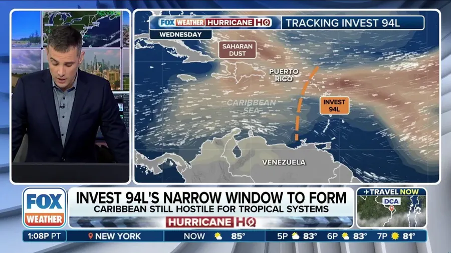
In meteorological terms, “Invest” is a label given to a weather system being monitored for potential tropical development. Invest 94L was initially identified over the western Caribbean and Yucatán Peninsula and had a moderate chance of organising into a tropical depression or storm.
As it moved northward into the Gulf of Mexico, atmospheric conditions became less favourable for intensification. Strong wind shear and dry air intrusion have weakened the system’s ability to consolidate.
The Invest 94L Gulf Coast Rain Threat remains relevant because even without becoming a named storm, tropical disturbances like this can dump large amounts of rain, especially in moisture-rich summer conditions.
Forecast: What Residents Can Expect This Week
Forecasters from the NHC and local meteorological offices predict that Invest 94L will bring widespread rain across the Gulf Coast. The system is expected to move northeastward and continue to affect the southeastern U.S. through the weekend.
Key Expectations:
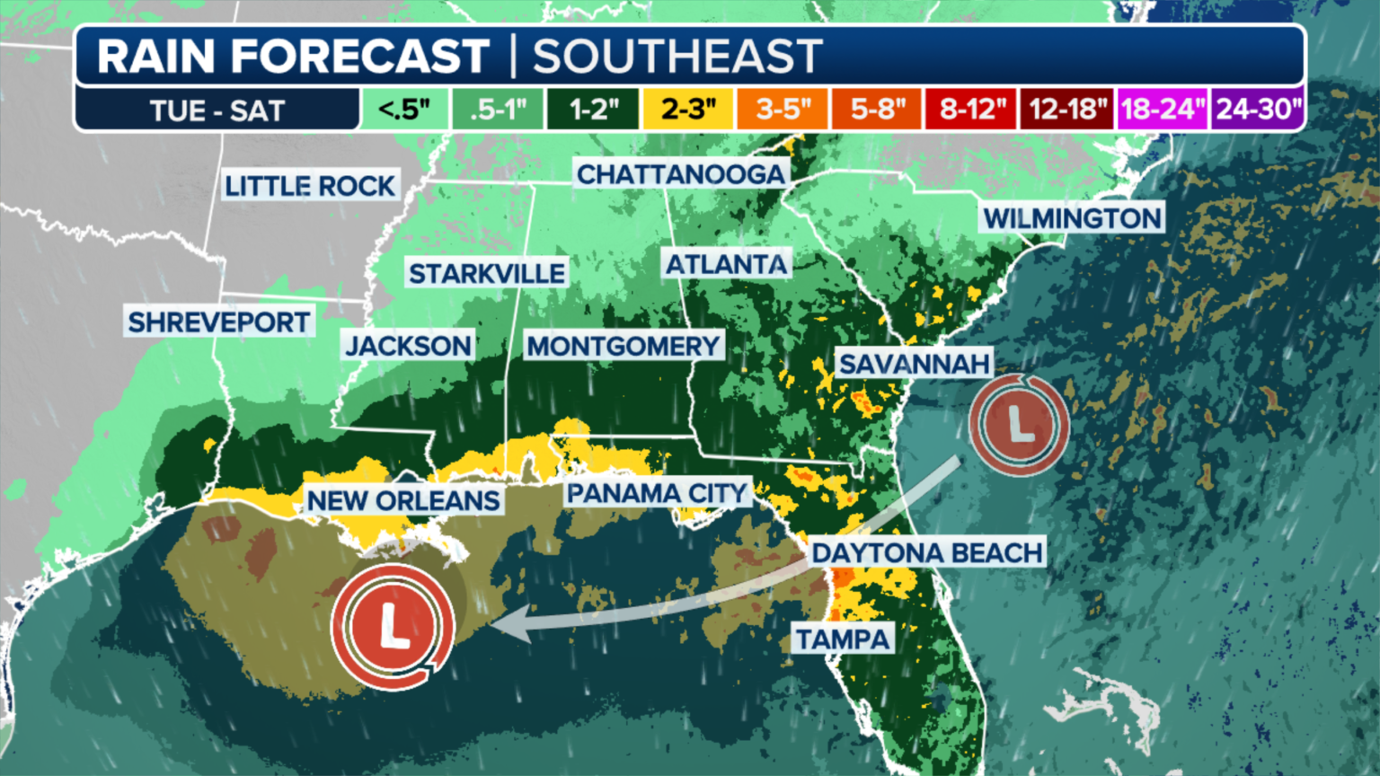
- Rainfall: Widespread totals of 2 to 5 inches, with isolated spots reaching 6 to 8 inches.
- Flash Flooding: Urban areas and poorly drained regions may see flash floods.
- Wind Gusts: 20–30 mph winds, especially near coastal regions.
- Rip Currents: Dangerous rip currents will be a risk along Gulf beaches.
Even though the Invest 94L Gulf Coast Rain Threat is losing strength, these impacts are significant and can disrupt travel, daily life, and outdoor plans.
Why Invest 94L Is Losing Strength
While there was some initial concern that Invest 94L could organise into a named storm, a combination of hostile environmental conditions led to its weakening.
Main Factors:
- Wind Shear: Upper-level winds are too strong and are tearing apart the storm’s structure.
- Dry Air: Dry air entering the system’s circulation is preventing thunderstorm development.
- Land Interaction: Its interaction with land along the Yucatán Peninsula and now the U.S. coastline has disrupted organization.
Because of these issues, the National Hurricane Center has downgraded its development probability from 60% to less than 20%.
Despite its downgrade, the Invest 94L Gulf Coast Rain Threat still holds the potential for flooding and weather disruptions in the coming days.
Current Status and Tracking Information
As of the latest update, the center of Invest 94L is located in the north-central Gulf of Mexico, drifting slowly toward the northern Gulf Coast.
Latest Stats:
- Location: Approximately 200 miles south of the Louisiana coast
- Movement: North-northeast at 10 mph
- Winds: Sustained winds of 25–30 mph
- Pressure: Estimated at 1008 mb
Radar images show widespread but disorganised storm activity over the Gulf. Coastal areas from eastern Texas to western Florida are likely to experience downpours throughout the week.
Preparedness Tips for Gulf Coast Residents
Even though Invest 94L Gulf Coast Rain Threat may not bring hurricane-force winds or storm surges, tropical rain events still pose serious threats.
Here’s What You Can Do:
- Stay Informed: Monitor local weather updates from the National Weather Service or reliable news sources.
- Avoid Flood Zones: If you live in a flood-prone area, keep a close eye on rain totals and be prepared to evacuate if needed.
- Secure Outdoor Items: Gusty winds may move loose items like trash bins or patio furniture.
- Drive Safely: Never attempt to drive through flooded roadways. “Turn around, don’t drown.”
- Emergency Kit: Keep a basic emergency kit ready in case of power outages or travel disruptions.
Will Invest 94L Develop Into a Named Storm?
The chances are now very low. According to NOAA forecasters, there is less than a 20% chance that Invest 94L Gulf Coast Rain Threat will turn into a tropical depression or storm in the next 48 hours.
However, the broad system still has an abundance of tropical moisture, and any bursts of thunderstorm activity could temporarily strengthen the rain bands.
While unlikely, forecasters are not ruling out short-lived development just before landfall.
Impact on Weekend Plans and Local Events
With the weekend approaching, many Gulf Coast residents are preparing for potential disruptions.
Affected Areas Include:
- New Orleans, LA: Rain expected Friday through Sunday
- Mobile, AL: Flash flood watch issued
- Pensacola, FL: High surf and rip current advisories in effect
- Houston, TX: Mostly unaffected but may see scattered showers
If you’re planning travel, beach outings, or outdoor events, the Invest 94L Gulf Coast Rain Threat means it’s time to rethink your schedule or prepare for interruptions.
Comparing Past Weather Systems to Invest 94L
While Invest 94L is not developing into a storm like Hurricane Ida or Tropical Storm Claudette, it serves as a reminder that not every tropical disturbance needs to be a named storm to be dangerous.
In 2021, a system similar to this dumped more than 10 inches of rain in parts of Alabama and Georgia without ever gaining tropical storm status.
The key lesson from the Invest 94L Gulf Coast Rain Threat is that rainfall and flooding—not just wind speed are major dangers from tropical systems.
What Comes Next After Invest 94L?
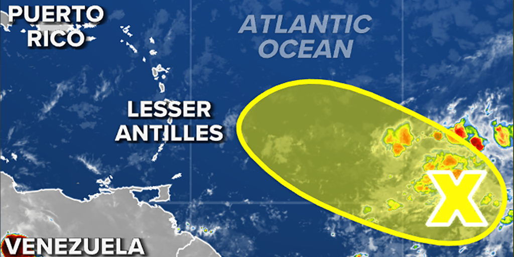
The Atlantic hurricane season officially runs from June 1 to November 30. Invest 94L is only one of several systems being monitored by meteorologists in 2025.
While this system is weakening, forecasters are already tracking a new tropical wave moving off the coast of Africa. Although it is too early to say whether it will pose a threat, the Invest 94L Gulf Coast Rain Threat is a clear reminder to stay alert throughout hurricane season.
Final Thoughts: Stay Weather-Ready
The Invest 94L Gulf Coast Rain Threat is gradually diminishing, but Gulf Coast residents should not let their guard down. Even a weak system can cause flooding, property damage, and safety hazards if people are unprepared.
Keep checking official weather sources and avoid rumors or misinformation on social media. Preparation and awareness are always your best protection.
Do follow Gulf Magazine on Instagram
Also Read – 3 Reasons This Saudi Chef Won 3.4M Fans With Kabsa & Joy