
In a groundbreaking study, researchers have successfully identified potential groundwater zones in Kuwait’s semi-arid regions by integrating advanced technologies such as Google Earth Engine (GEE), multi-criteria decision-making (MCDM), and geospatial techniques. This innovative approach offers a comprehensive method to locate and manage vital groundwater resources in areas where water scarcity is a pressing concern.
Kuwait, characterized by its arid and semi-arid climate, faces significant challenges related to water scarcity. With limited natural freshwater sources and increasing demand due to population growth and development, the need for effective groundwater management has become more critical than ever. Traditional methods of locating groundwater are often time-consuming and resource-intensive, necessitating the adoption of more efficient and accurate techniques.
The Challenge of Water Scarcity in Arid Regions
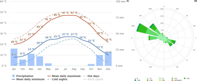
Kuwait’s climate is one of the harshest in the world, with minimal rainfall and high temperatures year-round. These conditions make it difficult for surface water bodies to exist, making groundwater one of the most vital sources of fresh water in the country. However, locating and managing groundwater reserves in such an arid environment has long been a challenge. Over-extraction and poor management of existing water resources further contribute to the depletion of available groundwater, leading to a dire need for advanced mapping and assessment techniques.
To tackle this problem, scientists have leveraged modern technology to conduct a detailed assessment of groundwater potential zones. By utilizing a combination of geospatial techniques, remote sensing, and advanced data analysis, researchers can now pinpoint areas with the highest likelihood of groundwater availability.
Integrating Modern Technologies for Groundwater Assessment
The research team, comprising experts from various institutions, employed a hybrid approach that combines GEE, MCDM, and geospatial analysis to assess groundwater potential zones in Kuwait. This methodology allows for the processing and analysis of large datasets, facilitating the identification of areas with the highest likelihood of groundwater presence.
Thirteen criteria were considered in the analysis, including:
- Geology
- Slope
- Rainfall
- Elevation
- Normalized Difference Vegetation Index (NDVI)
- Normalized Difference Water Index (NDWI)
- Land Surface Temperature (LST)
- Drainage density
- Land Use and Land Cover (LULC)
- Lineament density
- Topographic Wetness Index (TWI)
- Geomorphology
- Water table depth
By analyzing these factors collectively, the team was able to produce a detailed map highlighting areas with varying degrees of groundwater potential.
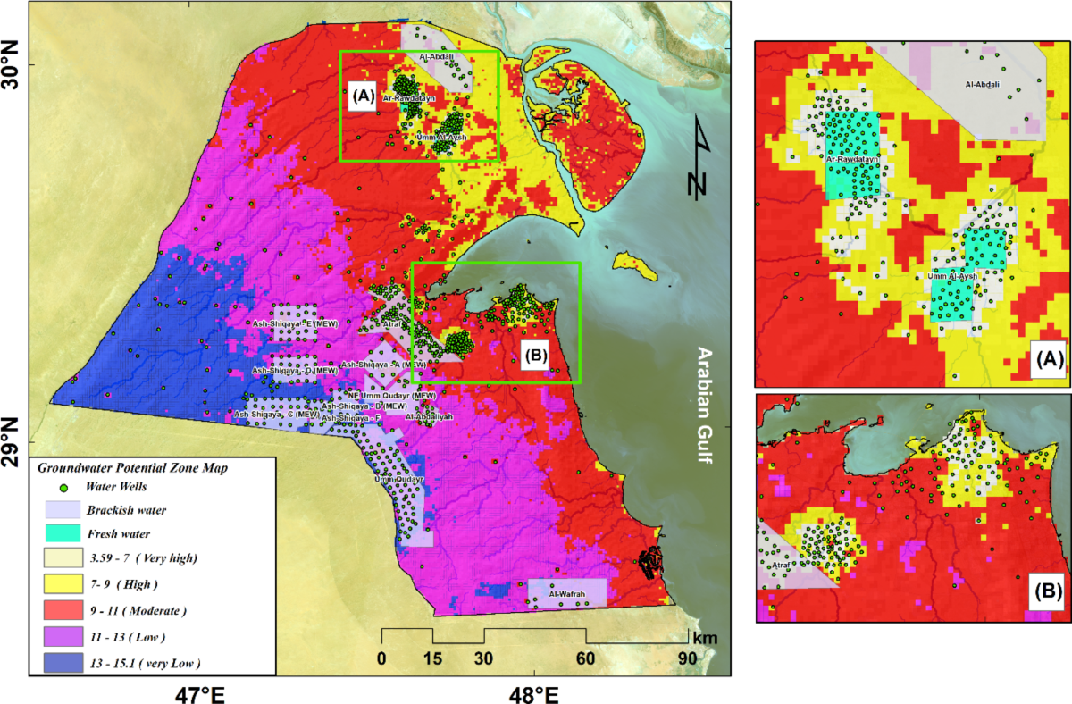
Key Findings: North and East Kuwait Show Promise
The study’s results indicate that the northern and eastern regions of Kuwait possess the highest potential for groundwater resources. Specifically, areas classified as having high and moderate suitability encompass approximately 12% and 37% of the country, respectively. Notably, zones with extremely high suitability constitute less than 1.5% of the total area. These findings suggest that while certain regions are promising for groundwater extraction, they represent a relatively small portion of the country’s landscape.
The analysis also revealed that over 7,500 square kilometers, nearly 50% of Kuwait’s total area, are classified as having low groundwater potential. This underscores the importance of targeted exploration and resource management in the more promising zones to ensure a sustainable water supply.
Validation Through Field Observations
To ensure the accuracy of their findings, the researchers conducted on-site field observations and compared their results with existing maps showing the distribution of productive groundwater wells in Kuwait. This rigorous validation process confirmed a strong alignment between the study’s predictions and actual groundwater occurrences, reinforcing the reliability of the hybrid assessment approach.
Implications for Future Water Resource Management
The successful integration of GEE, MCDM, and geospatial techniques in this study offers a replicable model for other arid and semi-arid regions facing similar water scarcity challenges. By adopting this approach, policymakers and water resource managers can make informed decisions regarding groundwater exploration and utilization, ultimately contributing to sustainable water management practices.
The researchers recommend extending the application of this methodology beyond the studied terrain and urge decision-makers to incorporate these findings into their strategic planning processes. By doing so, Kuwait can enhance its water security and better address the challenges posed by its arid environment.
The Importance of Sustainable Water Management
Groundwater is a finite resource, and if not managed properly, it can become severely depleted. Many countries around the world are facing similar challenges, where excessive groundwater extraction has led to severe environmental consequences, including land subsidence and declining water quality. Kuwait, with its limited water resources, must adopt sustainable practices to ensure the availability of groundwater for future generations.
The study highlights the need for efficient water policies and infrastructure to regulate groundwater extraction. Some of the recommended measures include:
- Implementing strict groundwater extraction regulations
- Enhancing recharge mechanisms to restore depleted aquifers
- Promoting water conservation programs
- Utilizing desalination in conjunction with groundwater extraction to reduce dependency on a single water source
- Developing advanced monitoring systems using remote sensing technology to track groundwater changes over time
By integrating these measures with the newly developed groundwater potential map, Kuwait can move toward a more sustainable and secure water future.
The Role of Technology in Water Resource Management
The use of advanced technologies like Google Earth Engine and geospatial mapping has revolutionized how we study and manage natural resources. These tools enable scientists to process vast amounts of data in real time, providing accurate and efficient insights into environmental conditions. By leveraging artificial intelligence, machine learning, and cloud computing, researchers can develop predictive models that help in proactive decision-making.
Such technological advancements are particularly beneficial for countries like Kuwait, where traditional methods of water exploration are not viable due to harsh climatic conditions. The ability to remotely assess groundwater potential without costly field surveys makes it easier for decision-makers to implement effective water management strategies.
Conclusion
This pioneering study demonstrates the potential of combining modern technologies to effectively assess and manage groundwater resources in challenging environments. As water scarcity continues to be a global concern, especially in arid regions like Kuwait, such innovative approaches are essential for ensuring the availability of this vital resource for future generations.
By embracing advanced mapping techniques and data-driven decision-making, Kuwait is taking a significant step toward securing its water resources. The findings of this study serve as a crucial roadmap for policymakers, researchers, and environmentalists working to address the pressing water crisis in arid regions worldwide. With continued research and investment in sustainable water management, Kuwait can build a resilient water supply system that supports its growing population and economic development.
GCC Nations Transform Hospitality Growth at Arabian Travel Market 2025